
OTISCO LAKE
Tuesday, April 13, 2010
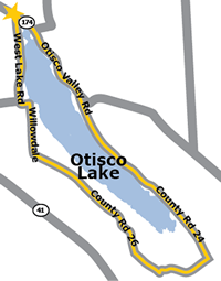
Having grown up near this man-made lake, I knew it well, particularly the number of hills on the west side. I chose to walk south on the west side, returning on the relatively flatter eastern shore road.
I parked just north of the dam at the Marietta House restaurant parking lot. Though the weather forecast an unseasonably warm temperature, I wore a sweatshirt in the morning chill. Following Route 174, I turned to Willowdale Road and headed south to walk down Moon Hill Road. This route took me east and out of sight of the lake along Saw Mill Road and on to Otisco Valley Road. As the sun climbed higher and the temperature reached sixty degrees, I tied the sweatshirt around my waist.
Continuing north, I noticed a fairly strong wind off the lake. I also realized that a small county park near the dam might have been a better parking spot.
During this first walk, I encountered residents and fishermen curious about the lone walker. They were surprised to hear my plan, and wished me well. When I mentioned that I was looking forward to a post-walk beer, they responded that I had earned at least two beers!
The eighteen-mile walk took about five hours and convinced me to continue my plan to walk the five main Finger Lakes during the coming year. In my mind, I had passed the first test.