
CANANDAIGUA LAKE
Wednesday, June 23, 2010
The walk around Canandaigua presented some real challenges and taught me a lot about planning. Just driving to and from the lake required more time.
Summer weather included higher temperatures, humidity, and the risk of dehydration. Long hills and greater distance from the lakeshore provided beautiful views but added miles to the walk.
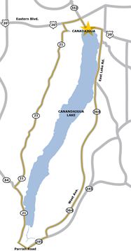
At five-thirty in the morning, I parked across from Canandaigua Lake State Marine Park and began walking away from the lake! This was the only way to reach West Lake Drive. The first few miles follow the shore and are quite pretty. Then Route 21 is up and down hills until it returns to the shore at the southern end. At a marina there, I bought water and took a snack break. Then I followed Parrish Road north of Naples and traversed Route 245 to continue northward. At that point, I realized that I needed more fluids and left my planned route to stop at Middlesex for water and iced tea. A young woman had passed me on the road and wondered why I was walking there. She was appropriately impressed to hear that I was walking around the entire lake.
From Middlesex, I took Route 364 and South Vine Valley Road up an enormous hill and closer to the lake which had been out of sight for the past four hours.
On yet another East Lake Road, I ran into trouble with dehydration and nausea. I lay down several times until I felt able to continue, finally reaching another marina and much-needed drinking water.
The blue shirt I’d worn was whitish-colored from the dried salt of my sweat. Happily, on Lakeshore Drive about a quarter mile from my car, a light rain began to fall. It felt good.
Fourteen hours had taken me forty-six miles, partly because of backtracking to stay close to the lakeshore. This was clearly the toughest walk I had attempted. But now it was done.